Source of article Litigation Insights.
A great many litigation cases benefit from the use of maps to illustrate relationships between objects, people, and spaces. In fact, maps offer such an efficient means to convey ideas to jurors that some verdicts can hinge on the strength of a map’s design.
But useful maps don’t come readymade. If you’re trying to explain a disastrous airplane flight path to the jury, for instance, you can’t point at the countryside topography (Figure 1) and fill in the scene with your words alone – poetic as you may be.
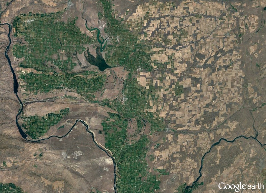
Fig. 1. A Google Earth image (data provided by Landsat/Copernicus) is detailed and accurate, but by itself doesn’t tell your story.
A carefully crafted map, on the other hand, with the right details in focus and unhelpful details eliminated – perhaps complete with animations to depict key events and changes? That’s when your case starts to become an accessible story.
Here are strategies for using maps to your best advantage:
What Maps Can Do in the Courtroom
Everyone has used maps (and their hi-tech offspring, mobile navigation) to get from Point A to Point B. We studied maps in school to learn state capitals and locate mountain ranges. We rely on them in subway stations, amusement parks, and shopping malls. The majority of the population are visual learners – we need guidance; we need to visualize.
You’ll notice that the best maps are custom solutions to custom problems, and that’s as true in the courtroom as anywhere. A customized map design is apropos when you need to depict any number of concepts, including:
- The route taken by a vehicle, and the corresponding events that unfolded along the way.
- Pollutants or illnesses that spread (or not) across an urban area.
- The blast radius of an explosion.
- Geological hazards, such as flood plains, in a specific residential area.
- Changes in city zoning ordinances and how they affected commercial development.
- Locations of safety features in an industrial workplace.
- Paths of civil infrastructure, such as water lines, and their repair history.
- Coverage zones for internet or cellular services.
In these scenarios and many more, literal representations of the spaces aren’t appropriate for telling an effective story. You need to curate the available information (to sort out what helps your case vs. distracts from it) and then enhance the raw data (through custom use of scale, detail, icons, lines/arrows, regions of color, animation, etc.) to create a winning demonstrative.
How to Make Your Maps Most Effective
Let’s imagine a hypothetical case where a pilot crashed a small aircraft. The plaintiff claims mechanical failure, the fault of the engine manufacturer. You represent the defense and are tasked to show that the plane ran out of gas due to imprudent behavior by the pilot, and that the crash could have been avoided.
Using maps, you can reveal to the jury how the pilot took an erratic route toward his destination – perhaps a sightseeing excursion – which led to excessive use of fuel. You can also demonstrate that even when the pilot realized he couldn’t make it to his original destination, there were several nearby airports where he could have safely landed.
What kinds of maps would be most effective for these tasks? See the following examples:
- Map #1: An aerial or satellite photo-based map (such as that same Google Earth image you saw earlier, presented again in Figure 2a below) will certainly provide a realistic view of the terrain, which lends authenticity. However, it won’t provide the most important details in and of itself.

Fig. 2a. BEFORE: Google Earth (data provided by Landsat/Copernicus) provides a foundation but needs additional graphics to be clear.
- This is where your graphics team comes in. They turn the Google Earth image into a storytelling device by adding icons, animations, and other visual elements. Now, jurors can see the direct flight path the aircraft should have taken, the path it actually took, and how the fuel level was affected as a result (Figure 2b). Taking this even further, you can build the narrative for the jury by fading in elements one at a time, moving the airplane along its path, dropping the fuel gauge as time passes, and so on.
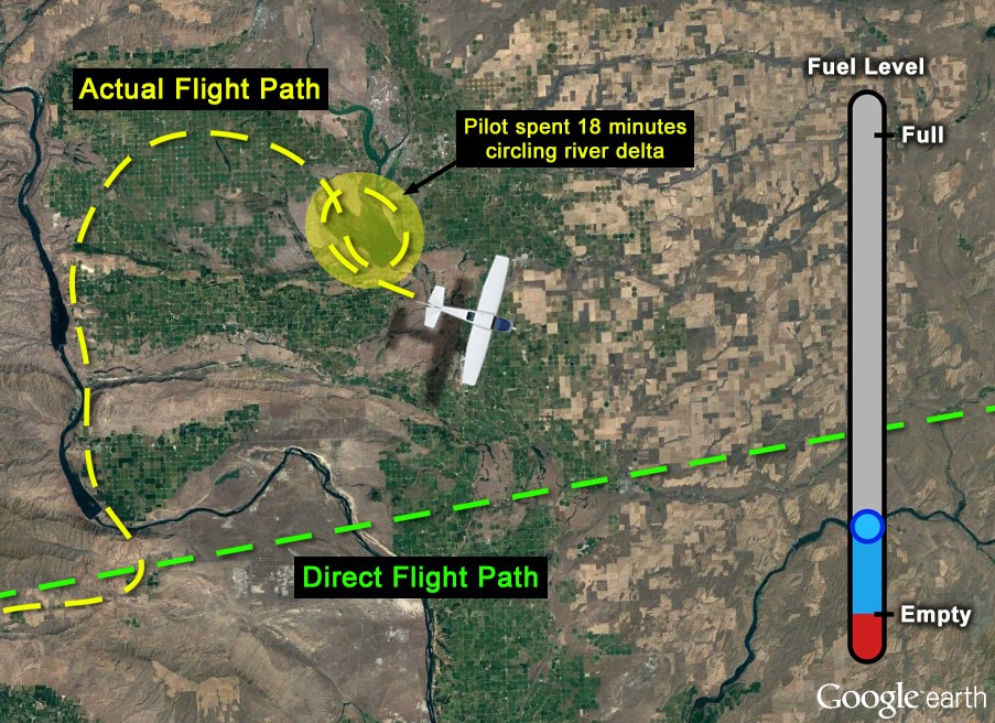
Fig. 2b. AFTER: Icons, labels, lines, and graphs turn satellite imagery into a visual narrative.
- Map #2: The flight path map tells the first half of the story – but another map is needed to complete the narrative. In this case, you know that there were several places the pilot could have safely landed, even after spending most of his fuel sightseeing. You determine that an aeronautical map – with which the pilot should have familiarized himself during his pre-flight procedure – is an effective way to show applicable airports nearby. The primary challenge with these maps, however, is that most jurors have never seen one before, and the visual density would quickly overwhelm them (Figure 3a).
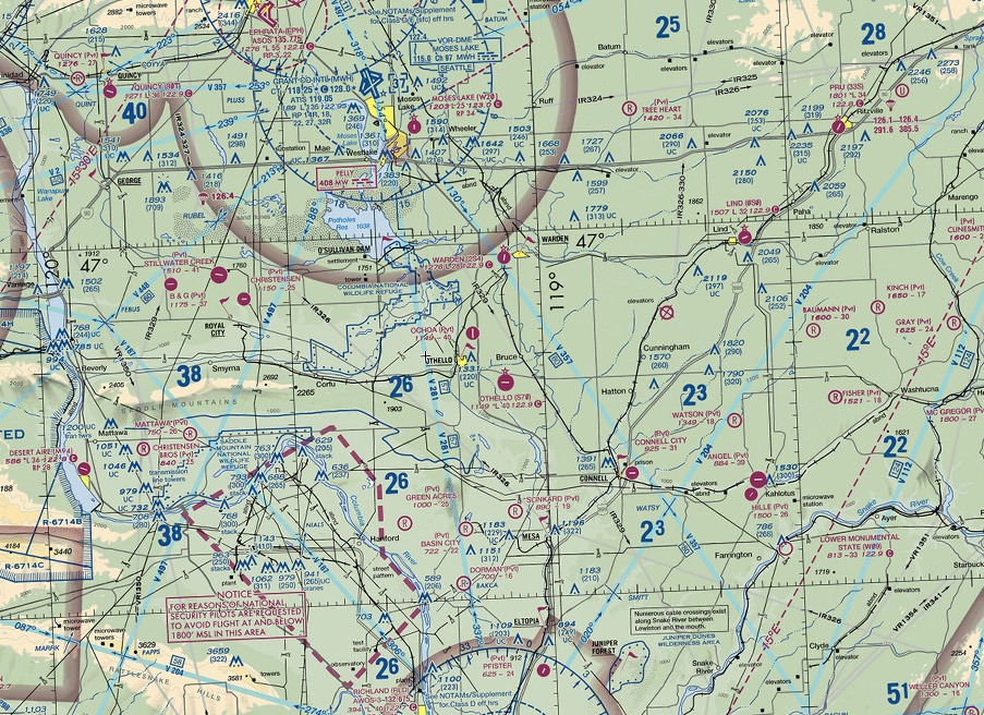
Fig. 3a. BEFORE: An aeronautical map of the area (from VFRMap.com) has useful information
but is visually complex.
To avoid this problem, the graphics team fades non-essential elements into the background, highlights airports within reach of the plane, and adds a map legend to help jurors understand unfamiliar symbols, as in Figure 3b. Even a cursory study of the image makes it clear there were several safe landing options available.
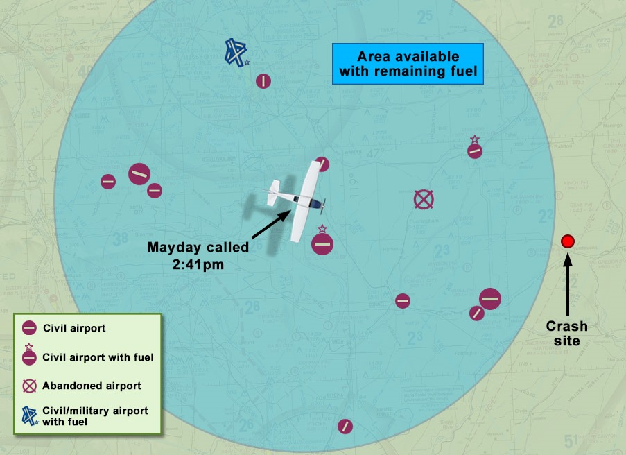
Fig. 3b. AFTER: Reducing visual noise, highlighting the essentials, and adding instructive elements.
Conclusion
These are just two examples of how maps can be tailored for the courtroom. There are many situations where maps are the best choice for making your narrative compelling and clear for the jury – and qualified litigation graphics artists will be familiar with the visual storytelling tools that map-making provides. When you’re next confronted with the task of illustrating objects and people across space, consider a custom-designed map as your ace in the hole.

By: Shannon Gilley – Senior Designer / Animator
The post How to Use Map Graphics Effectively in Litigation appeared first on Litigation Insights.